Project “Whale Safe”
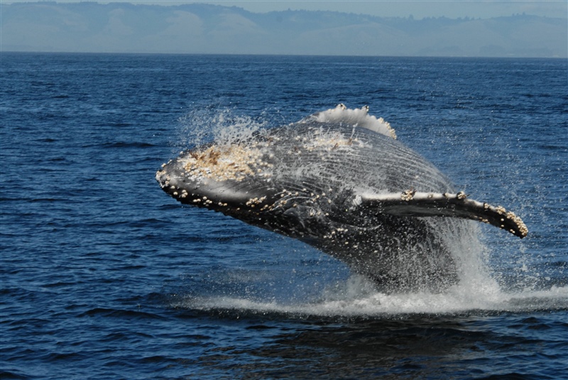
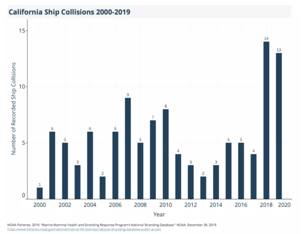
Whales are a key component of a thriving ocean ecosystem, impacting food webs, supporting coastal economies, and helping to mitigate climate change. Ship collisions are currently a leading cause of death for large whales around the world. Along the US West Coast, scientists estimate that out of all the large whales in this region, which include blue, humpback, and fin whales, over 80 are killed by vessel collisions each year. Unfortunately, whale-ship collisions are occurring at increasing rates with 27 strikes reported in 2018 and 2019 combined. Scientists estimate that only 5-17% of whale carcasses are detected and recorded, so the actual number is likely much higher (Rockwood et al. 2017).
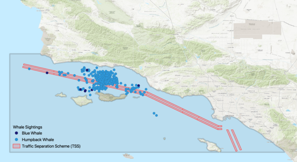
To reduce whale-ship collisions, Whale Safe is a decision support tool that shares near real-time whale and ship data to inform ships transiting when to slow down to avoid whale collisions. Whale Safe is a large collaborative effort led by the Benioff Ocean Initiative, who teamed up with ocean scientists from several other organizations, including University of Washington, the University of California Santa Cruz, Woods Hole Oceanographic Institution, Texas A&M University at Galveston, and the National Oceanic and Atmospheric Administration (NOAA). Whale Safe is currently deployed in the Santa Barbara Channel, California, one of the US’s biggest hotspots for ship strikes. The Santa Barbara Channel is one of the busiest port complexes in the world with over 2500 large cargo ships traversing it annually, but it also serves as an important feeding ground and migratory route for blue, fin, and humpback whales, the first two considered endangered or threatened (IUCN Red List). Whale Safe is now being expanded to the San Francisco Bay Area, California, the second busiest port and hotspot for ship strikes along our coast.
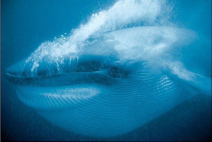
Blue whales are of particular concern for ship strikes due to their large size and endangered status. The blue whale is the largest animal on earth, averaging between 70-90 feet and weighing between 100-150 tons. For this population to recover to a sustainable level, NOAA has determined deaths from human-caused incidents need to remain below two blue whales per year. Unfortunately, every year approximately 18 blue whales in this population are likely killed by ship collisions alone. Research has shown that reducing a ship’s speed is one of the best ways to protect whales from collisions (Vanderlaan and Taggart 2006).
Marine shipping, however, is increasing due to the need for raw materials in the global market. Transportation routes for these ships often pass through whale habitats, bringing them into close contact with whale populations. These ships are often quite large, reaching up to 1,000 ft long and 15 stories tall, making it difficult for captains and crews to spot whales with enough time to respond. Ships need to know when and where to slow down in order to reduce whale-ship collisions. Whale Safe does that through providing the shipping industry with a straightforward data-driven assessment of whale presence in the Channel.
Whale Safe uses three technologies to achieve its goal: an AI powered acoustic monitoring system to detect whale calls; a mobile app used by community scientists to record whale sightings; and a big data model led by Dr. Briana Abrahms of the UW’s Center for Ecosystem Sentinels, which provides near real-time forecasts of whale presence probability. Dr. Abrahms’ research, published in Diversity and Distributions (Abrahms et al. 2019), related the movements of more than 100 blue whales, tracked with temporary satellite tags by Oregon State University, to daily oceanographic conditions such as sea surface temperature and water column properties. The data showed that whales respond predictably to specific ocean conditions that create good habitat for them and their prey. Her model is used to estimate the probability of blue whales along the west coast based on the current day’s ocean conditions, like a daily weather forecast for whales.
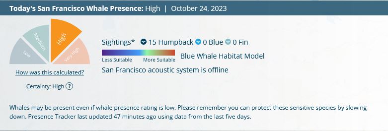
Each day, the data from these three sources are combined into an integrated whale presence rating (low, medium, high, very high) for the region. It not only shows when large whale species are definitely present and have been recorded, but also when whales are likely to be in the region given the current oceanographic conditions.
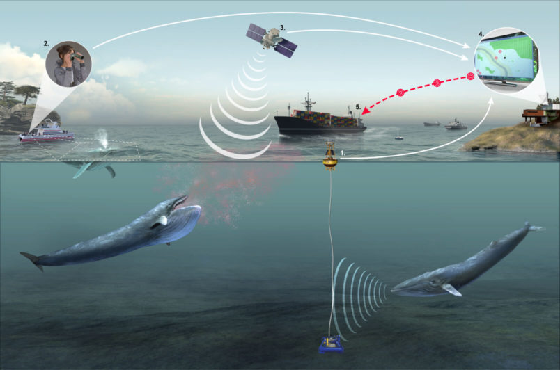
In addition to sharing whale data, the Whale Safe system also integrates ship-tracking data, designated shipping lanes, speed reduction zones, and shipping activity derived from Automatic Identification Systems (AIS) on-board transiting ships. The AIS system works like a GPS tracking system and is used by large ships to navigate and avoid collisions. Through integrating this information, the public are able to monitor which ships and companies are slowing down to protect endangered whales. Whale Safe provides a letter grade to shipping companies based on how “Whale Safe” their shipping speeds are.
Currently Whale Safe has only been deployed off the coast of California, but it has potential to be replicated in other ship strike hotspots around the world. To prioritize the next hotspot, Dr. Abrahms and her collaborators are currently mapping whale distributions overlaid with shipping traffic around the world. Innovative technology such as this has the potential for reducing ship strikes, allowing these fragile populations a chance to recover.
More information can be found on the Whale Safe website.
Literature Cited
Abrahms, B., Welch, H., Brodie, S., Jacox, M. G., Becker, E. A., Bograd, S. J., Irvine, L. M., Palacios, D. M., Mate, B. R., & Hazen, E. L. (2019). Dynamic Ensemble models to predict distributions and anthropogenic risk exposure for highly mobile species. Diversity and Distributions, 25(8), 1182–1193. https://doi.org/10.1111/ddi.12940
Rockwood, R. C., Calambokidis, J., & Jahncke, J. (2017). High mortality of blue, humpback and fin whales from modeling of vessel collisions on the U.S. West Coast suggests population impacts and insufficient protection. PLOS ONE, 12(8). https://doi.org/10.1371/journal.pone.0183052
Vanderlaan, A. S., & Taggart, C. T. (2006). Vessel collisions with whales: The probability of lethal injury based on vessel speed. Marine Mammal Science, 23(1), 144–156. https://doi.org/10.1111/j.1748-7692.2006.00098.x